PHILADELPHIA — Following the 2025 Philly Bike Ride, I explored on the Schuylkill Banks trail south of Eakins Oval. Part of the Schuykill River Trail1, a partially completed trail planned to cover the 145 miles of the river, this section is 4.5 miles long. It’s part of the East Coast Greenway.
Downstream
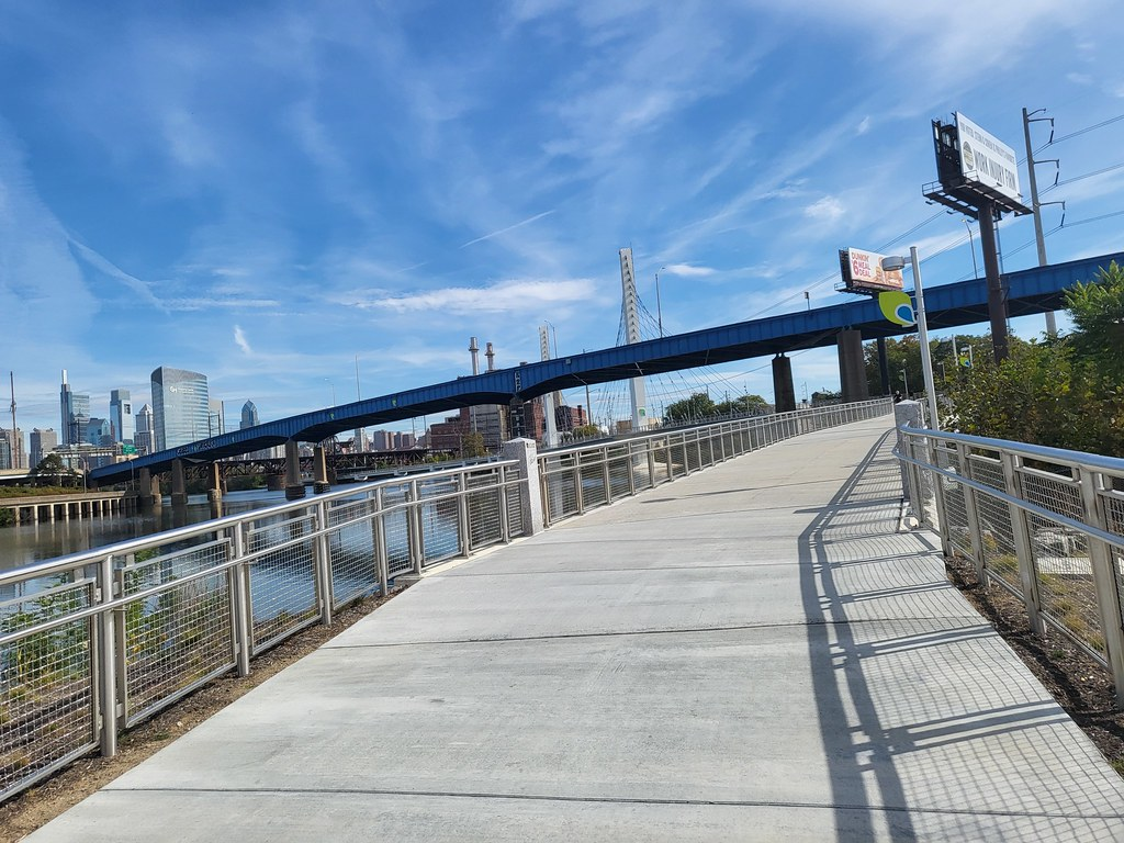
What struck me on the first mile south of the Oval was how many runners I saw. I don’t know if was an organized running group(s) or just very popular. It’s with good reason too as it’s along the river with great views of bridges, 30th Street Station, the University of Pennsylvania and more.
Constrained by the river and an active, two-track freight railroad, the trail goes over the water on a section called the boardwalk. It’s about ½ mile and goes under the South Street Bridge before returning to land.

Another ⅓ mile down the trail is the Christian to Crescent cable-stayed bridge. At 650 feet long, it’s the iconic portion of the trail, adding to the overall cityscape as the trail once again proceeds over the water. After touchdown, the trail goes under the Schuykill Expressway (I-76) and then around Grays Ferry Crescent.
The Banks trail diverts to the Grays Ferry Road bridge over the river. A repurposed swing span rail bridge is currently under construction. Officially, it’s slated for last this year, but my eye suggests it’s going to be 2026.

Detour
The temporary portion breaks off from Grays Ferry Road to Paschall Ave., following the T5/Route 36 trolley line. I didn’t see any trolleys during my ride though. Periodic ECG signs provide wayfinding lead the way, turning left to 49th St. for about 1,000 feet crossing the Northeast Corridor on overpass. At Grays Ave., the bike lane turns down an industrial corridor. There is a cycletrack on the eastern side, but it was full of trucks and cars. The motorized traffic on a Saturday afternoon made that a non-factor.

At 51st St. the trail goes left, though isn’t signed southbound. 51st is has old industrial buildings on either side before being surrounded by vacant lots. The surface hasn’t been addressed in some time, but it could be worse. Less than ½ mile later, at the intersection of Botanic Ave. the trail emerges with its own right of way. To the right is Bartrams Garden, the final portion of the completed Schuykill Banks Trail. To the left, a stub that will connect to the new bridge at Grays Ferry.
Bartram’s Gardens
The southern-most portion of the completed trail alternates between its own right-of-way and sharing pavement with trail access roads. It’s low stress but has some hills.
Bartram’s Gardens is “home for horticulture, the oldest surviving botanic garden in North America, an ancient riverfront, Sankofa Community Farm, high school internship programs, and a place of untold histories.”
Unfortunately, the free kayaks were not available due to chromium levels in the river.2
The trail ends in Batram’s Gardens for now. It’s proposed to reach Fort Mifflin on the Delaware River. I look forward to bicycling the completed portion someday.

The Schuykill Banks logo
Is it just me or goes this look like something a water utility would use for a logo? It may be rotated 180° first.
The Circuit Trails
The Schuykill River Trail is one part of what is known as the Circuit Trails. Created by The Delaware Valley Regional Planning Commission34, the plan is eventually reach over 800 miles of trails. It’s quite impressive in ambition.
As of this year, there are 415.9 miles of open trails. That’s an impressive number and will only become more so.
It’s probably worth noting that bicycling is responsible for my last two trips to Philadelphia and quite possible my next one. Take note, skeptical politicos.


2025 Philadelphia trip
I visited the City of Brotherly love in October.
Footnotes
- Philly Bike Ride paralleled the Schuykill River Trail up to the Falls Bridge. ↩︎
- I was looking forward to adding the Schuykill and Philadelphia to my Elsewhere section of dckayaking.com. ↩︎
- DVRPC is the federally designated Metropolitan Planning Organization for the Greater Philadelphia region, established by an Interstate Compact between the Commonwealth of Pennsylvania and the State of New Jersey. ↩︎
- Does anybody actually refer to the area as the Delaware Valley other than this commission and mass media? I kind of don’t think so. ↩︎